Due to a lapse in appropriations, the majority of USGS websites may not be up to date and may not reflect current conditions. Websites displaying real-time data, such as Earthquake, Volcano, LANDSAT and Water information needed for public health and safety will be updated with limited support. Additionally, USGS will not be able to respond to inquiries until appropriations are enacted. For more information, please see www.doi.gov/shutdown.

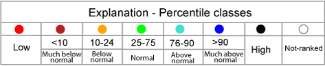
Map of 28-day average streamflow compared to historical streamflow for the day of the year (South Dakota)

or

sd
05049000 06480000 06479525 06479500 06478500 06477000 06476000 06475000 06473000 06472000 06471500 06471200 06450500 06449500 06449100 06449000 06439000 06395000 06386500 05293000 05292000 05291000 05290000 05050000 06412810 06485500 06482020 06441500 06438000 06437000 06436000 06428500 06422500 06421500 06402000 06360500 06359500 06357800 06356500 06334500 06486000 06436198 06436190 06482610 06482000 06481500 06479438 06479010 06478690 06477500 06466500 06464500 06464100 06453600 06452320 06452000 06447500 06447230 06447000 06445685 06440200 06438500 06437020 06436180 06434505 06433000 06431500 06430850 06430800 06430770 06430500 06429997 06425500 06425100 06423500 06414000 06412500 06411500 06410500 06410000 06409000 06408700 06407500 06406500 06406000 06404998 06404000 06403300 06355500 06485910 06483950 06481480 06481000 06480650 06479770 06479520 06479215 06478600 06478513 06478000 06471800 06471000 06447450 06446700 06446500 06446000 06442600 06442130 06436170 06418800 06408650 06403700 06402600 06402500 06401500 06400875 06400000 06354881 05051600
Choose a data retrieval option and select a location on the map
map legend