Due to a lapse in appropriations, the majority of USGS websites may not be up to date and may not reflect current conditions. Websites displaying real-time data, such as Earthquake, Volcano, LANDSAT and Water information needed for public health and safety will be updated with limited support. Additionally, USGS will not be able to respond to inquiries until appropriations are enacted. For more information, please see www.doi.gov/shutdown.

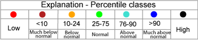
Map of monthly streamflow compared to historical streamflow for the month of the year (United States)

or

us
wa id mt me or mn nd mi nh wi vt ny sd wy ma ca ct ri nv pa ia ut ne oh nj il in co wv de md va mo dc ks ky az nc nm tn ok tx ar sc ga al ms la fl ak hi pr vt nh ma ri ct nj de md dc

Choose a data retrieval option and select a location on the map
,   , or  
map legend