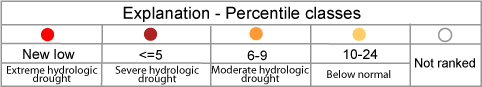
Map of below normal 14-day average streamflow compared to historical streamflow for the day of year (Wyoming)

or

wy
09255000 06622700 06224000 13011500 09196500 09188500 06635000 06630000 06623800 06620000 06306300 06235500 06037500 13022500 13018750 13016450 13011900 13010065 10039500 10032000 10020100 09257000 09253000 09223000 09217900 09211200 09210500 09209400 09205000 06646000 06634620 06632400 06430500 06428500 06305700 06228350 06228000 06218500 06191000 06186500 06036905 13046995 13027500 13023000 13018300 13011000 10038000 10020300 10011500 09224700 09220000 09218500 09217000 09213500 06674500 06670500 06660000 06657000 06652000 06625000 06430850 06429997 06426500 06324500 06318500 06317000 06309200 06289000 06285100 06281000 06279940 06279500 06274300 06253000 06227600 06221400 06207500 06188000 13025500 13018350 13016305 13015000 13014500 13013650 10028500 10016900 09258980 09258050 09229500 09215000 06638090 06634060 06630465 06386500 06236100 06220800 06209500 06190540 06187915 06037100 06036940 06036805
Choose a data retrieval option and select a location on the map
List of all stations Single station Nearest stations
map legend