Due to a lapse in appropriations, the majority of USGS websites may not be up to date and may not reflect current conditions. Websites displaying real-time data, such as Earthquake, Volcano, LANDSAT and Water information needed for public health and safety will be updated with limited support. Additionally, USGS will not be able to respond to inquiries until appropriations are enacted. For more information, please see www.doi.gov/shutdown.

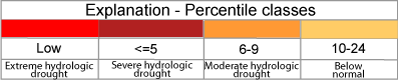
Map of below normal 7-day average streamflow compared to historical streamflow for the day of year (Colorado)

below normal 7-day average streamflow condition map

Click map to obtain more detailed drought information for the state

map legend