Due to a lapse in appropriations, the majority of USGS websites may not be up to date and may not reflect current conditions. Websites displaying real-time data, such as Earthquake, Volcano, LANDSAT and Water information needed for public health and safety will be updated with limited support. Additionally, USGS will not be able to respond to inquiries until appropriations are enacted. For more information, please see www.doi.gov/shutdown.

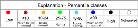
Map of 7-day average streamflow compared to historical streamflow for the day of the year (North Dakota)

or

nd
06471200 06469400 06354000 06353000 06349500 05124000 05122000 05101000 05099400 05082625 05057200 05054000 05050000 06342260 06470800 06468250 06468170 06354580 06349000 06345500 06340500 06339500 06335500 05120000 05117500 05116000 05114000 05113600 05090000 05085000 05059700 05059500 05058500 05057000 05056000 05054500 05053000 05051522 05051300 06344600 06329500 06470878 06470500 06470000 06352000 06350000 06348300 06345780 06342500 06340000 06339100 06337000 06336000 06332770 06332515 06332000 06331000 05123400 05116500 05100000 05099600 05092000 05084000 05082500 05069000 05067500 05066500 05064500 05064000 05062000 05059480 05059300 05059000 05058700 05058000 0505152130 06354480 06354050 06351200 06349600 06348500 06347500 06347000 06343000 06342450 06340590 06340010 06336600 06335750 06332523 05123510 05120500 05070000 05065500 05060500 05060400 05060100 05060000 05059715 05059600 05059310 05056678 05056340 05056239 05056215 05056200 05056100 05056060 05055400 05055300 05052500 05052000 05051600 05051500 05046475
Choose a data retrieval option and select a location on the map
map legend