WaterQualityWatch -- Continuous Real-Time Water Quality of Surface Water in the United States

Real-Time Specific Conductance, in µS/cm

Map of , showing which states provide real-time computed water-quality data
11455820 373015122071000 372507121594801 375607122264701 374811122235001 11162765 11455780 381142122015801 11455508 11128500 11261500 11044000 09429490 11262900 11126000 11176900 11273400 11261100 11125605 11455095 11126400 11304810 11455142 11274550 11463682 11458433 11337190 11455136 10260500 10261500 11463980 11313433 11455485 11204100 11274790 11455385 11447905 11447650 11465240 11467000 11336685 11313315 11251000 11455140 11455338 11303000 11447903 11203580 11290000 11510700 11312676 11461500 11336600 11313405 11447890 11336790 11455276 11462500 11336680 11455315 11133000 380631122032201 11274500 10260950 384115121402501 10336698 374938122251801 11452900 11452800 11074000 11452500 375603122254401 11451800 11511990 Explanation

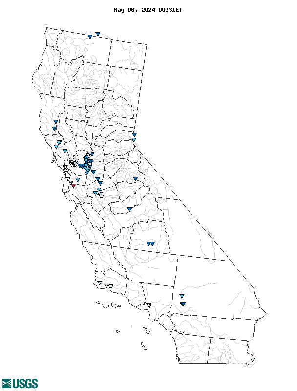
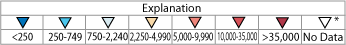
* Site operated on a seasonal basis or currently is not operating.
No values are available for the last 6 hours.

The "Real-time" map tracks short-term changes (over several hours) of water quality. Although the general appearance of the map changes very little from one hour to the next, individual sites may change rapidly in response to major rain events or to reservoir releases. The data used to produce this map are provisional.