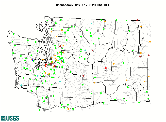
WaterQualityWatch -- Continuous Real-Time Water Quality of Surface Water in the United States

Real-Time Discharge, in cfs

Map of , showing which states provide real-time computed water-quality data
12431500 12452500 12113346 14216500 12433200 12431000 12424000 12117500 12116500 12026150 12178000 12101100 12090400 12396500 14220500 14219800 14216000 14211720 14113200 14113000 14103000 14033500 14015000 14013000 13351000 13345000 13335050 13333000 12472800 12472600 12467000 12464800 12419000 12409000 12175500 12148000 12119000 12117600 12089500 12059500 12056500 12026400 12465000 12456500 12448500 12447390 12181000 12091500 12091200 12090500 12089208 14246900 14243000 14242580 14238000 14236200 14233500 14231000 14226500 14222500 14219000 14123500 14120000 14105700 14018500 13348000 13344500 13334300 12510500 12508990 12502500 12500450 12488500 12484500 12462500 12459000 12458000 12457000 12452800 12451000 12449950 12449500 12447200 12445000 12442500 12439500 12422500 12404500 12401500 12399500 12395000 12213100 12208000 12205000 12201500 12200500 12194000 12193400 12189500 12186000 12179900 12167000 12155300 12150800 12149000 12148500 12148300 12147600 12145500 12144500 12144000 12143900 12143700 12143600 12143400 12142000 12141300 12138160 12137800 12137290 12135000 12134500 12121600 12120600 12117000 12116100 12115700 12115500 12115000 12114500 12113000 12112600 12106700 12105900 12102190 12101500 12099600 12097850 12097500 12095000 12094000 12093500 12092000 12091100 12088000 12087000 12086500 12083000 12082500 12080010 12079000 12073500 12061500 12060500 12054000 12048000 12045500 12043300 12043000 12041200 12040500 12039500 12037400 12036000 12035400 12035000 12031000 12027500 12025700 12025000 12024000 12020000 12013500 12010000 1203951610 14240525 14240446 14240311 14240304 14231900 14219950 14218480 14217599 14211820 14211814 14211400 14144700 14142800 14128895 14128870 14128600 14111400 14013800 14013700 13317660 12513000 12506000 12505450 12471000 12470000 12469500 12465400 12452990 12452890 12452000 12451200 12448998 12448000 12447383 12447285 12446995 12446400 12446150 12445900 12445500 12444550 12444290 12439000 12438905 12436000 12434590 12426000 12422990 12422000 12396455 12395950 12214500 12212430 12212050 12211200 12211195 12210900 12210700 12210220 12210000 12209490 12202450 12202400 12202310 12202300 12201960 12201950 12199000 12190400 12182500 12179000 12178100 12177700 12176500 12175000 12170300 12161000 12158040 12158032 12158010 12157250 12155500 12150400 12147900 12147470 12131500 12122000 12118400 12116400 12115900 12113415 12113390 12113350 12113349 12113347 12113344 12108500 12105800 12101470 12101102 12101000 12100500 12100498 12100496 12100494 12100490 12099200 12098920 12098500 12098000 12097820 12096865 12096505 12096500 12091290 12086000 12076800 12058790 12052210 12043163 12043015 12039510 12039005 12036400 12035450 12035380 12035100 12028060 12025100 12024400 12021800 12020800 12020525 Explanation

* Site operated on a seasonal basis or currently is not operating.
No values are available for the last 6 hours.

The "Real-time" map tracks short-term changes (over several hours) of water quality. Although the general appearance of the map changes very little from one hour to the next, individual sites may change rapidly in response to major rain events or to reservoir releases. The data used to produce this map are provisional.