Calculation of Hydrologic Unit Code (HUC) runoff
Estimates of hydrologic unit runoff were generated by combining historical flow data collected at USGS streamgages, the respective drainage basin boundaries of the streamgages, and the boundaries of the 2,110 hydrologic cataloging units. Streamgages for the analysis were selected for each water-year based on the availability of a complete daily flow dataset for the water-year. Geospatial data representing drainage basin divides for each streamgage location were delineated using the NHDPlus dataset and the accompanying digital elevation model (DEM) based flow direction information (USEPA and USGS, 2005). Basin boundaries with a computed drainage area within 25% of the streamgage drainage basin area reported in the USGS National Water Information System (NWIS) (USGS, 2008) were considered valid for this analysis. In a typical water-year during the period 1971-2000, there were about 6,000 streamgages with a complete daily flow dataset and an acceptable drainage basin boundary. The drainage basin areas of these streamgages ranged from 10 to 180,000 km2 with a median value of 3,000 km2.
Hydrologic cataloging units and associated 8-digit accounting numbers (HUC8s) are a widely used geographic framework for the conterminous United States. Each unit defines a geographic area representing part or all of a surface drainage basin or a combination of drainage basins. Cataloging units subdivide larger accounting units (HUC6s), subregions (HUC4s) and regions (HUC2s) into smaller areas designated by the U.S. Water Resources Council and the USGS's National Water Data Network. Cataloging units range in size from 24 to 22,808 km2 with a median value of 3,133 km2 (Seaber et al., 1987; Steeves et al., 1994).
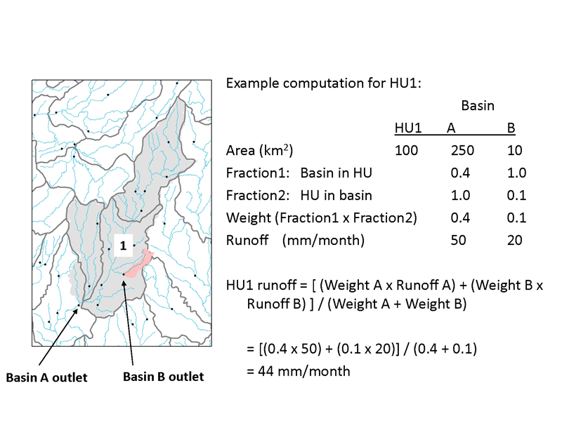
The figure below illustrates the method used to compute runoff estimates for HUC8s. The first step is to compute runoff values (flow per unit area) for each streamgage basin by dividing the average daily flow for the water-year by the delineated basin area. In the hypothetical example, runoff is estimated at two streamgages (labeled A and B in the figure) by dividing the average daily flow measured at each of two streamgages by their respective drainage basin areas. (The drainage area of basin A is shaded light gray and the drainage area of basin B is shaded dark gray. Note that drainage basin B is nested within drainage basin A).
Each geospatial basin boundary is then overlain on a geospatial dataset of HUC8s (the polygons outlined in bold black lines) to determine the area of intersection within the two datasets. For each overlapping area of HUC8s and drainage basin boundaries, the fraction of the basin in the HUC8 and the fraction of the HUC8 in the basin are calculated. These fractions are then multiplied by each other to compute a weighting factor for each basin. The runoff values and associated weighting factors for all basins with any overlapping area with a HUC8 are combined, and a single weighted-average runoff value is computed for the HUC8.
The weighted-average runoff computations illustrated in the figure were repeated for all combinations of the roughly 6,000 basins and 2,100 hydrologic cataloging units (HUC8s). Runoff values for HUC8s which had no overlapping areas with streamgage basins were computed as the mean of the HUC8 runoff values within the same HUC4 (subregional unit).
Figure showing example computation for HUC1 runoff (from Brakebill and others, 2011)
References:
Brakebill, J.W., D.M. Wolock, and S.E. Terziotti, 2011. Digital Hydrologic Networks Supporting Applications Related to Spatially Referenced Regression Modeling. Journal of the American Water Resources Association(JAWRA) 47(5):916-932.
Seaber, P.R., F.P. Kapinos, and G.L. Knapp, 1987. Hydrologic Unit Maps. U.S. Geological Survey Water Supply Paper 2294, 63 pp. http://pubs.usgs.gov/wsp/wsp2294/#pdf, accessed February 2009.
Steeves, P. and D. Nebert, 1994. 1:250,000 Scale Hydrologic Units of the United States. U.S. Geological Survey Open-File report 94-0236. http://water.usgs.gov/GIS/metadata/usgswrd/ XML/huc250k.xml, accessed June 2008.
USEPA (U.S. Environmental Protection Agency) and USGS (U.S. Geological Survey), 2005. National Hydrography Dataset Plus (NHDPlus). ftp://ftp.horizon-systems.com/NHDPlus/documentation/ metadata.pdf, accessed December 2009.
USGS (U.S. Geological Survey), 2008. National Water Information System (NWIS): Web Interface. http://waterdata.usgs.gov/nwis, accessed May 2008.