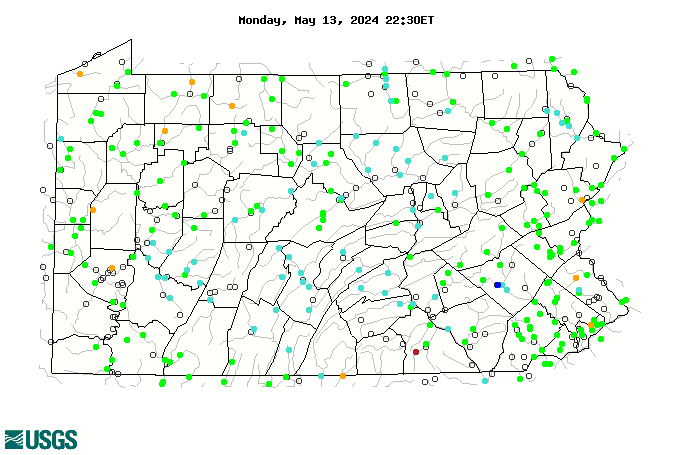
WaterQualityWatch -- Continuous Real-Time Water Quality of Surface Water in the United States

Real-Time Discharge, in cfs

Map of , showing which states provide real-time computed water-quality data
01619000 01574500 01480685 03021520 01576500 01575500 01573160 01572025 01480675 01480617 01480500 01479820 01467087 01467081 01449800 03045000 03030500 01553700 01481500 01481000 01480870 01480700 01477800 01476480 01475850 01473000 01467086 03106300 03101500 01464645 01443900 03085500 03081000 03074500 03072655 03049800 03048500 03044000 03027500 01576754 01573560 01573000 01571500 01570000 01563200 01547500 01547100 01546400 01495000 01480300 01475530 01474500 01474000 01473900 01473169 01472157 01472000 01471510 01471000 01470960 01470779 01468500 01467048 01467042 01465798 01464000 01452500 01452000 01451650 01451500 01449360 01445500 04213075 03109500 03107500 03106500 03105500 03103500 03102850 03086000 03079000 03049500 03047000 03042500 03042280 03040000 03039000 03036500 03036000 03031500 03029500 03028500 03028000 03026500 03025500 03024000 03023100 03022554 03021350 03020000 03016000 03015500 03015000 03012550 03011800 03010655 03007800 01601000 01578310 01576000 01570500 01567500 01565000 01563500 01559000 01558000 01557500 01554000 01553500 01552000 01551500 01550000 01549700 01549500 01548500 01547950 01547700 01547200 01546500 01545600 01545500 01545000 01544500 01544000 01543500 01543000 01542810 01542500 01541200 01540500 01539000 01536500 01536000 01534500 01534300 01534000 01533400 01532000 01531500 01520500 01520000 01518862 01518700 01518000 01477000 01472620 01469500 01464720 01463500 01459500 01454700 01453000 01451800 01451000 01450500 01449000 01447800 01447720 01447680 01447500 01446500 01446000 01443500 01442500 01440400 01440000 01439500 01438500 01434000 01431500 01430000 01429500 01429000 01428750 01428500 01427510 01427500 01425000 01421000 015765195 014755456 04213152 03111950 03110830 03110690 03108500 03108490 03108000 03106280 03106000 03104490 03103400 03102950 03102500 03099500 03098700 03086001 03085947 03085734 03085730 03085250 03085213 03085152 03085002 03085000 03084800 03084698 03083500 03082500 03081500 03080000 03078000 03077500 03077000 03076600 03076500 03075071 03075070 03075000 03074998 03074850 03073751 03073750 03073000 03072656 03072000 03071600 03063000 03062998 03049819 03049807 03049681 03049680 03049641 03049640 03049501 03048900 03046500 03045010 03044810 03043500 03042000 03041500 03041029 03041000 03040100 03040050 03039041 03039040 03039036 03039035 03038500 03038000 03036501 03036151 03036150 03035500 03034500 03034000 03033289 03033215 03033001 03033000 03032500 03031882 03031624 03029000 03028900 03027000 03026480 03022550 03022540 03021890 03021518 03021410 03020500 03019500 03017500 03015310 03012520 03010955 03010500 01614500 01613525 01613095 01613050 01613000 01610155 01601500 01581960 01581830 01578475 01577500 01576787 01576767 01574700 01574000 01573849 01573825 01573710 01573695 01573600 01572190 01571184 01571005 01568000 01567000 01566000 01564895 01564512 01564500 01563100 01562000 01560000 01559790 01556000 01555500 01555000 01553990 01553850 01553240 01553025 01553005 01552500 01550500 01549760 01548005 01547480 01545800 01544800 01543900 01543700 01543693 01541500 01541340 01541303 01541180 01541000 01538700 01538510 01538000 01534860 01534490 01534180 01531908 01531325 01531250 01531000 01530332 01525981 01519995 01519200 01518498 01518420 01517900 01516500 01516350 01515000 01514850 01513550 01503000 01502731 01494850 01480400 01480399 01478650 01478245 01478120 01475553 01475548 01474501 01473800 01473500 01472810 01472199 01472198 01471875 01470870 01470755 01470500 01465500 01465200 01464984 01464907 01464750 01462000 01461500 01458500 01457500 01449790 01447780 01446995 01446776 01446775 01441495 01440485 01440200 01439590 01432160 01432110 01429400 01428900 01427207 01426500 Explanation

* Site operated on a seasonal basis or currently is not operating.
No values are available for the last 6 hours.

The "Real-time" map tracks short-term changes (over several hours) of water quality. Although the general appearance of the map changes very little from one hour to the next, individual sites may change rapidly in response to major rain events or to reservoir releases. The data used to produce this map are provisional.