USGS Science for a changing world

This summary is published as USGS Fact Sheet FS-2011-3043 and can be downloaded as a PDF file

Streamflow of 2010 - Water Year Summary

U.S. Geological Survey
Reston, Virginia

January 2011

national stramflow rank
national stramflow

Introduction

The maps and graph in this summary describe streamflow conditions for water-year 2010 (October 1, 2009 to September 30, 2010) in the context of the 81-year period 1930-2010, unless otherwise noted. The illustrations are based on observed data from the U.S. Geological Survey's (USGS) National Streamflow Information Program. The period 1930-2010 was used because prior to 1930, the number of streamgages was too small to provide representative data for computing statistics for most regions of the country.

In the summary, reference is made to the term "runoff," which is the depth to which a river basin, State, or other geographic area would be covered with water if all the streamflow within the area during a single year was uniformly distributed upon it. Runoff quantifies the magnitude of water flowing through the Nation's rivers and streams in measurement units that can be compared from one area to another.

Each of the maps and graphs below can be expanded to a larger view by clicking on the image. In all the graphics, a rank of 1 indicates the highest flow of all years analyzed.

National Overview

national stramflow

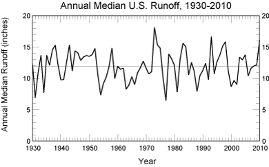
  Runoff in the Nation’s rivers and streams during 2010 (16.10 inches) was much higher than the long-term annual median for the United States (11.98 inches). Nationwide, 2010 streamflow ranked 3rd out of the 81 years in the period 1930-2010.
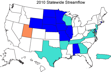
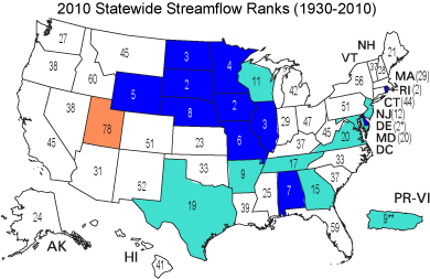
statewide rank

wet-dry bar
  Above normal and much-above normal streamflow characterized most parts of the Midwest and Southeast, and also Puerto Rico. Below normal streamflow was prevalent only in Utah.

* Out of 72 years of historical data.
** Out of 67 years of historical data.

Regional Patterns

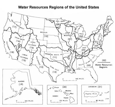
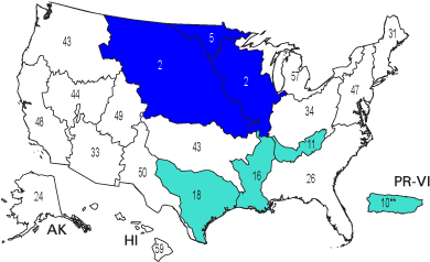
HUC 2 map   The United States (including Puerto Rico) is divided into 21 large drainages, or water resources regions. These hydrologic areas are based on surface topography and contain either the drainage area of a major river, such as the Columbia, the combined drainage areas of a series of rivers, such as the Texas-Gulf region which includes a number of rivers draining into the Gulf of Mexico, or the area of an island or island group. Water resources regions provide a coherent, watershed-based framework for depicting streamflow variations.
Regional patterns

rank bar
  Streamflow was in the normal range in most of the Nation’s water resources regions. Much-above normal flows dominated Missouri, Upper Mississippi, and Souris-Red-Rainy regions. Above normal flows were reported in Texas-Gulf, Lower Mississippi, Tennessee, and Caribbean regions.

Seasonal Characteristics

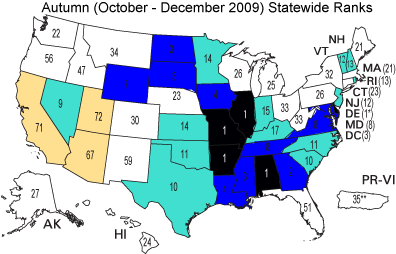
October-December statewide ranks   Nationwide, autumn season (October-December) streamflow was at record high levels (ranking 1st in 81 years). Individual states with record high autumn flows included Illinois, Missouri, Arkansas, Alabama, and Delaware. Above and much-above normal flows were reported in 10 and 13 states, respectively, while below normal flows were observed in only three states (California, Nevada, and Utah).

* Out of 72 years of historical data.
** Out of 67 years of historical data.

January-March statewide ranks
 
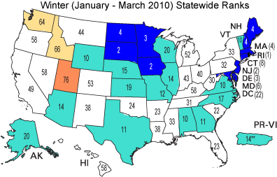
Winter season (January-March) streamflow was above or much-above normal in many central states, southeastern states, parts of New England, Alaska, and Puerto Rico.  Below normal and much-below normal streamflow occurred in Utah, Idaho, and Washington.  Nationwide, winter season streamflow ranked 4th out of 81 years.

* Out of 72 years of historical data.
** Out of 67 years of historical data.

April-June statewide ranks
 
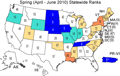
Spring season (April-June) streamflow was above or much-above normal in the north-central states and Puerto Rico. In contrast, some northeastern and southern states reported below or much-below normal flows.  On a nationwide basis, spring season streamflow was above normal, ranking 42nd in 81 years.

* Out of 72 years of historical data.
** Out of 67 years of historical data.

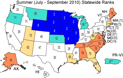
July-September statewide ranks

rank bar


Nationwide, summer season (July-September) streamflow was above normal, ranking 24th out of 81 years. However, a broad range in flow conditions from state to state was observed.  Much-above normal streamflow prevailed in most north-central states, while much-below normal flows dominated the Southeast, Northeast, Arizona, Nevada, and Alaska. 

* Out of 72 years of historical data.
** Out of 67 years of historical data.

High and Low Flows

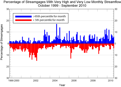
high and low flows

In any given month, on average, it is expected that five percent of the streamgages will experience very high (>95th percentile) and very low (<5th percentile) average streamflow.  During water year 2010, eight months (October, November, December, January, March, June, July, and September) had a greater than expected percentage of streamgages reporting very high streamflow (12, 8, 13, 7, 12, 8, 7 and 6 percent, respectively).  In contrast, there were no months with a greater than expected percentage of streamgages with very low flows.
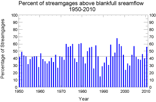
percentage above bankfull streamflow   The bankfull streamflow is defined as the highest daily mean streamflow value expected to occur, on average, once in every 2.3 years. In 2010, 56 percent of streamgages had a daily mean streamflow value above the bankfull level. This value is greater than the expected number (43 percent) to occur in any given year. Since 1950, the largest number of streamgages reporting higher than bankfull streamflow in any one year was 68 percent, which occurred in 1996.
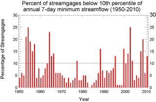
percentage above 10th percentile of annual 7-day minimum streamflow  

The 10th percentile 7-day low flow is defined as the lowest 7-day average streamflow expected to occur, on average, once in every 10 years. In water-year 2010, 13 percent of the streamgages reported a 7-day low flow less than the 10th percentile 7-day low flow. The expected number to occur in any given year is 10 percent. Since 1950, the largest percentage of streamgages reporting a 7-day low flow less than the 10th percentile 7-day low flow was 25 percent, which occurred in 1954 and 2002.

Additional Information

The USGS operates a network of approximately 7,600 streamgages nationwide, many in real-time. Current information derived from these stations is available on the web at http://waterwatch.usgs.gov. Tables of data that summarize historical streamflow conditions by State, beginning in the year 1900, can be accessed at http://waterwatch.usgs.gov/?m=statesum. These tables are updated every few months to reflect the most current streamflow data.

The streamflow information used to prepare this summary is also used for water management, monitoring floods and droughts, bridge design, and for many recreational activities. To obtain real-time and archived streamflow data and information, visit http://water.usgs.gov/nwis. Although the national streamgage network is operated primarily by the USGS, it is funded by a partnership of 850 agencies at the Federal, State, Tribal, and local levels. For more information about the streamgage network, see http://water.usgs.gov/nsip/.

For additional information, contact:
  Harry Lins
U.S. Geological Survey
415 National Center
Reston, VA 20192
Email: hlins@usgs.gov